Difference between revisions of "Road"
(→Major Roads: Raktam - Wiksik is well maintained (or was)) |
m (→Major Roads) |
||
| (One intermediate revision by the same user not shown) | |||
| Line 9: | Line 9: | ||
The current best maintained roads are: | The current best maintained roads are: | ||
| − | *The [[Dalpok]]-[[York]] road - Southeast from [[Dalpok]] until | + | *The [[Dalpok]]-[[York]] road - Southeast from [[Dalpok]] until {{GPS|70|369|26|381}}, then South |
| − | *The [[Durham]]-[[York]] road - East from [[Durham]] until | + | *The [[Durham]]-[[York]] road - East from [[Durham]] until {{GPS|70|401|26|350}}, then Southeast |
*The [[Shipwreck]]-[[Dalpok]] road - Southeast from the [[Shipwreck]] | *The [[Shipwreck]]-[[Dalpok]] road - Southeast from the [[Shipwreck]] | ||
| − | *[[Raktam]]-[[Wiksik]] road - Southeast from [[Raktam]] | + | *The [[Raktam]]-[[Wiksik]] road - Southeast from [[Raktam]] |
Other roads that still exist but are not well maintained are: | Other roads that still exist but are not well maintained are: | ||
| − | *[[Derby]]-[[York]] road - From [[ | + | *[[Derby]]-[[York]] road - From [[Derby]], it cuts through the [[river]] avoiding the [[swamp]], and after a long West trek the same treatment is applied to the Yorkish [[river]], before meeting the [[Dalpok]]-[[York]] road. |
*[[Raktam]]-[[Dalpok]] road - West from [[Raktam]], hugs the [[mountain]] before turning South. | *[[Raktam]]-[[Dalpok]] road - West from [[Raktam]], hugs the [[mountain]] before turning South. | ||
*[[York]]-[[Unity Island]] road - follows the [[Durham]]-[[York]] road,then branches NorthWest to minimize swim distance. | *[[York]]-[[Unity Island]] road - follows the [[Durham]]-[[York]] road,then branches NorthWest to minimize swim distance. | ||
Latest revision as of 22:10, 3 January 2009
A road is a lane of cleared jungle that may also cut through grassland, river, etc., which is used to quicken travel for those without trekking and prevent those without a GPS unit from getting lost. Tigers and highwaymen are major threats, and caution should be taken to avoid them by resting in any available ruin or out of sight of the trail. It is common courtesy to chop any vegetation on whatever squares you walk on.
Major Roads
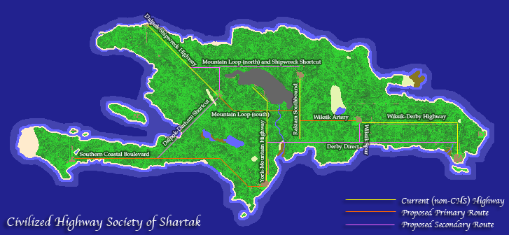
Road maintenance has always been performed, but the best to to this as of yet is the Civilized Highway Society. This is what they envisioned for shartak:
Unfortunately, the inactivity of most of their members has caused road upkeep to fall into disorder, with only a handful of ununited people working at any one time. The Ubermap can show you the current situation.
The current best maintained roads are:
- The Dalpok-York road - Southeast from Dalpok until [-70.369,+26.381], then South
- The Durham-York road - East from Durham until [-70.401,+26.350], then Southeast
- The Shipwreck-Dalpok road - Southeast from the Shipwreck
- The Raktam-Wiksik road - Southeast from Raktam
Other roads that still exist but are not well maintained are:
- Derby-York road - From Derby, it cuts through the river avoiding the swamp, and after a long West trek the same treatment is applied to the Yorkish river, before meeting the Dalpok-York road.
- Raktam-Dalpok road - West from Raktam, hugs the mountain before turning South.
- York-Unity Island road - follows the Durham-York road,then branches NorthWest to minimize swim distance.
