File:Dr j mountain L2.png
From The Shartak Wiki
Revision as of 11:43, 7 March 2006 by Dr. J (talk | contribs) (Mountain map at level 2, where ground level is level 0. Light blue is mid-air, medium blue is waterfall, grey is mountain, green is jungle. Some of the lighter jungle areas do show where paths down the mountain exist, but not all of them are paths and s)
No higher resolution available.
Dr_j_mountain_L2.png (420 × 248 pixels, file size: 1 KB, MIME type: image/png)
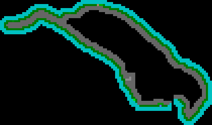
Mountain map at level 2, where ground level is level 0.
Light blue is mid-air, medium blue is waterfall, grey is mountain, green is jungle.
Some of the lighter jungle areas do show where paths down the mountain exist, but not all of them are paths and some paths aren't shown. Tunnels are light grey.
File history
Click on a date/time to view the file as it appeared at that time.
| Date/Time | Thumbnail | Dimensions | User | Comment | |
|---|---|---|---|---|---|
| current | 11:43, 7 March 2006 | | 420 × 248 (1 KB) | Dr. J (talk | contribs) | Mountain map at level 2, where ground level is level 0. Light blue is mid-air, medium blue is waterfall, grey is mountain, green is jungle. Some of the lighter jungle areas do show where paths down the mountain exist, but not all of them are paths and s |
- You cannot overwrite this file.
File usage
The following page uses this file: