Difference between revisions of "User:Lint/Sandbox"
From The Shartak Wiki
Jump to navigationJump to searchm |
|||
| Line 1: | Line 1: | ||
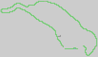
| − | == | + | == Mountain Path == |
| + | [[Image:Mountainpath.gif]] | ||
| + | |||
| + | == Small Cave-Tunnel == | ||
{| cellpadding="8" cellspacing="1" style="background-color: #e0e0e0" | | {| cellpadding="8" cellspacing="1" style="background-color: #e0e0e0" | | ||
| − | | colspan="9" bgcolor="#f9f9f9" | '''Small Cave | + | | colspan="9" bgcolor="#f9f9f9" | '''Small Cave-Tunnel - Territory Map''' |
|- | |- | ||
| bgcolor=#666666|01 | | bgcolor=#666666|01 | ||
Latest revision as of 17:20, 1 June 2006
Mountain Path
Small Cave-Tunnel
| Small Cave-Tunnel - Territory Map | ||||||||
| 01 | 02 | 03 | 04 | 05 | 06 | 07 | 08 | 09 |
| 02 | ||||||||
| 03 | ||||||||
| 04 | ||||||||
| 05 | ||||||||
| 06 | C | |||||||
| 07 | ||||||||
| Legend | ||||||||
| Unincorporated ("Jungle") | ||||||||
| Mountain | ||||||||
| Tunnel [-70.339,+26.429] | ||||||||
| C | Small Cave [-70.333,+26.425] | |||||||
Waterfall Ledge
| Waterfall Ledge - Territory Map | |||||||||||||||
| 01 | 02 | 03 | 04 | 05 | 06 | 07 | 08 | 09 | 10 | 11 | 12 | 13 | 14 | 15 | 16 |
| 02 | |||||||||||||||
| 03 | W | ||||||||||||||
| 04 | |||||||||||||||
| Legend | |||||||||||||||
| Unincorporated ("Jungle") | |||||||||||||||
| Mountain | |||||||||||||||
| Mid air | |||||||||||||||
| W | Waterfall [-70.351,+26.429] | ||||||||||||||
