File:JohanCrichtonShartakMap.png
From The Shartak Wiki
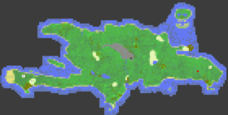
Revision as of 00:53, 8 February 2009 by Johan Crichton (talk | contribs) (A map of the 5164 areas on the island (142.3% of island) 2009-02-08.)

Size of this preview: 800 × 406 pixels. Other resolutions: 320 × 162 pixels | 840 × 426 pixels.
Original file (840 × 426 pixels, file size: 8 KB, MIME type: image/png)
A map of the 5164 areas on the island (142.3% of island) 2009-02-08.
File history
Click on a date/time to view the file as it appeared at that time.
| Date/Time | Thumbnail | Dimensions | User | Comment | |
|---|---|---|---|---|---|
| current | 00:53, 8 February 2009 | | 840 × 426 (8 KB) | Johan Crichton (talk | contribs) | A map of the 5164 areas on the island (142.3% of island) 2009-02-08. |
- You cannot overwrite this file.
File usage
There are no pages that use this file.